


A public-private consortium has already pumped in $400 million for 5G research in Canada. How are telecom operators moving forward?
The next-generation wireless network, or 5G, is being hailed as a quantum leap in telecommunications technology which will make download speeds 100 times faster than present-day. But 5G is not about streaming 4K movies in a flash alone. The technology will bring major advances in sectors that rely heavily on real-time data (finance, utilities, transportation, public safety, etc.) as well as connected industries like the Internet of Things and self-driving cars.
So, it’s no surprise that the governments of Canada, Ontario and Quebec are joining hands with private companies like Ericsson, Ciena Canada, Thales Canada, IBM and CGI to create a $400-million 5G research fund. This investment will be used to set-up an array of research labs which will test products and services running on 5G networks.
To be clear, 5G mass deployment in the Canadian market is not expected until 2020. This is because 5G requires an infrastructure which is vastly different from past wireless technologies.
5G is fueled by small-cell technology. Its main component is as small as a shoebox and the accompanying hardware no bigger than a refrigerator. This is the same tech that powers 4G, but on a very small scale. 5G requires 10 to 100 times more antenna locations than those needed by 4G or 3G networks, simply because its signals cannot travel as far as old radio frequencies can.
To draw an analogy, imagine 5G as an e-commerce giant. Instead of trying to cater to a wide region with a single central warehouse, it spreads out its inventory into small dispatch units. So, when the holiday season comes and orders go up, it is able to serve customers much more quickly and efficiently. Similarly, in the 5G universe, if one cell site is compromised, other cell sites help to meet the demand.
Since Canadian telecom operators will be investing quite heavily into 5G antennas, foolproof cell site selection is a necessity rather than a choice. Here, a location intelligence platform can prove to be a telecom business’ best friend because it can help the business to identify 5G cell sites based on definitive criteria, such as:
In order to maximize network coverage and make sure their investment would get the highest possible returns, telecom operators would want to install 5G antennas at places that have a large number of residents. These population clusters can be clearly mapped by a location intelligence platform. Moreover, telecom companies would also get access to detailed insights on population growth trends, which would allow them to future-proof their plans.
With network providers racing to take the lead in 5G rollout and adoption, it is imperative for them to know where exactly their existing clients are and upsell 5G to them. Not only can precise location information help make this process a breeze, but network providers would also be able to enhance customer satisfaction and build greater loyalty for their brand.
5G is expensive, we have already established that. And even though telecoms may not have finalized the rates at which they will offer the technology to the end consumer, it makes good business sense to invest in the area which houses an affluent population. A location intelligence platform can help telecoms zero down on hotspots of high median income effortlessly.
Progressive telecom companies know the importance of tapping into points of interest (POI) data to supplement their revenues. A location may be in the suburbs, but if it frequently plays host to large-scale events or music festivals, telecoms would want to make sure their services are available in that area. Visualizing these POIs on the map can help companies make sure they don’t lose out on business from these high-demand sites.
An important factor that simply cannot be ignored while selecting cell site locations to deploy the 5G infrastructure is the accessibility of that place. Uninterrupted service can only be assured if the technical team has uninterrupted access to a cell site. Here, a location intelligence platform can assist by mapping out all possible 24/7 entry and exit options for the crew.
Proper knowledge and understanding of zoning regulations and local laws are imperative for a smooth 5G rollout. Instead of scrambling for information from different sources, network providers can easily use a location intelligence platform to collate various laws, and draw out insights like which sites allow installations for commercial use at the click of a button.
While there is no doubt that 5G is inflaming a technological revolution in Canada, the market is completely up for grabs. It would be interesting to see which progressive telecom operator beats the competition by leveraging a location intelligence platform loaded with rich data and unparalleled insights.
Contact us to learn more.

Read to know why location technology and location data sets are indispensable weapons in any retailer’s artillery

Insurance is a competitive industry, and when everyone is offering the same services for similar value, there’s only one thing that sets you apart: branding. We’ve talked about how spatial technology helps improve customer experience for insurance companies, but did you know a great customer experience could also be part of how your company brands itself? Branding an insurance company ensures customers know you prioritize their satisfaction, and that’s what makes your company unique from everyone else.
A great customer experience is an incredibly valuable market differentiator. Statistics show that companies known for providing strong customer experiences have more loyal customers, stronger word of mouth referrals, higher profits, and better customer retention than companies scoring lower on overall customer experience.
Leveraging the right technologies to support customers is essential. Spatial technology can play a powerful role in branding an insurance company as a leader in providing great customer experiences.
Insurance companies know how important it is to provide great customer experiences, but it turns out most of them aren’t meeting expectations. Insurance-Canada recently published an article based on the J.D. Power 2018 Insurance Digital Experience Study, discussing how insurance companies are falling short on digital customer engagement.
The study found 3 key areas where most insurance companies fail customer expectations. Here they are, with an explanation of how a spatial technology platform can help:
The study showed that most companies have attractive websites, but are lacking in digital offerings such as processing claims, effective shopping and servicing of policies. Modern consumers expect to do everything online, and potential customers get frustrated by what they perceive as a disjointed experience on most insurance websites.
How a Spatial Technology Platform Helps: A strong spatial technology platform interfaces with your company’s website and customer service software to stream current, updated property information that aligns with digital queries. Data feeds into the rules and parameters set by your company’s underwriters. This allows you to automate the digital shopping process from end-to-end.
Insurers that tailored insurance offerings to customers’ specific needs scored higher in the study than those who did not. These companies are able to offer precise guidance on insurance plans that will best serve the customer.
How a Spatial Technology Platform Helps: Instant access to spatial data helps personalize the underwriting process and insurance offerings by delivering a complete overview of customer portfolios and property information for properties anywhere in the country. This information presents the big picture analysis of a customer’s property ownership history and current needs, allowing you to effectively review risk and offer the appropriate services to serve them with minimal input from them.
Customers want an insurance website that’s easy to navigate and instantly get the information they need in a clear, understandable format. Customers want providers to offer a range of services that can be completed online.
How a Spatial Technology Platform Helps: Spatial technology platforms feed into your company’s software, allowing you to use spatial data for quick and efficient digital services, but also to provide the information customers are looking for. Additionally, spatial data is continually updated, ensuring that customers are working with only the most current, accurate information.
A strong spatial technology platform has the ability to address all of these common customer grievances, while protecting your company’s rules and workflows. This ensures coverage remains consistent with the risk selection and pricing models developed by your company’s actuarial/risk group.
Leveraging customer experience tactics to brand your company and set it ahead of your competition helps you deliver on modern consumer expectations. Spatial technology allows insurance companies to develop engaging, seamless experiences that support what customers want, need and expect.
DMTI is the gold standard for GIS and location-based data in Canada, offering insurers scalable on-demand tools that support real time workflows. DMTI Spatial’s Location Hub® & UAID® is the only solution of its kind in Canada, and supports you company’s risk assessment process by delivering data visualization tools, and data delivery infrastructure to provide high-precision location accuracy.
Click here to find out how DMTI can help your insurance company become known for providing amazing customer experiences.

As cities around the world embrace the changes wrought by digital technologies, there’s still a lot of confusion about what it means to be a smart city. Generally characterized as an urban area that uses data and technology to improve operational efficiency, smart cities promise to enhance how people relate to their environment.
Smart cities are developed by technologists and urban planners who gather and analyze information to improve problem areas. These can include traffic, pollution, public safety, public health and wellness, sustainability, and much more. Institutions like schools, hospitals, power plants, and waste management are able to use data to optimize operations and operate quickly and efficiently.
Being a smart city can mean many things and it can look very different depending on where you are, but the objective is always the same – using technology to create a sustainable future and improve people’s quality of life.
Smart cities feature a combination of technologies including the Internet of Things (IoT), artificial intelligence (AI), mobile technology, networks of embedded sensors that read and respond to data, the semantic web, and many other platforms that interface with one another. These technologies are employed to gather actionable data and improve efficiency.
Examples of smart city technologies include alerts to help people find parking more easily, or the ability to change traffic patterns in real time to respond to peak congestion. It can include systems that monitor air quality in buildings and automatically engage air purification systems when necessary, or systems that automatically harness natural sources of power like wind and solar energy. Smart city technology can even help preserve resources by detecting gas or water leaks, instantly sending alerts to engage the appropriate department.
Most government agencies, whether municipality, federal or provincial, struggle to effectively communicate with residents. Smart city technology aims to solve this problem by finding new ways to engage with residents to more easily understand their needs and serve them more effectively.
Digital mapping is an example of how many governing agencies engage technology to communicate more efficiently. Digital mapping provides a platform to easily integrate, consolidate and analyze data quickly to monitor assets and streamline workflows for great efficiency. It’s a simple way to provide visual information to residents about their community, while also offering them the ability to input observations and experiences and get feedback in real time.
A major benefit of the data cities gather using smart technologies is the ability to generate predictive analytics to improve safety and identify problems before they happen. Spatial technology plays an important role here, providing accurate, updated hazard data to monitor and identify risks quickly.
An example of this is the ability to monitor for the likelihood of fire by using spatial technology to review various data points layered onto a map. This information can easily illustrate new construction, or older buildings that haven’t been updated to meet current safety codes and standards. These areas could serve as a potential warning in need of being carefully monitored to mitigate the risk of fire.
With current estimates showing that 70% of the world’s population will live in cities by 2050, measures to improve safety and sustainability are critical. Growing populations put pressure on government agencies to ensure cities are functioning at optimal levels.
Whereas smart city technology was once pegged for large cities, urban areas large and small are instituting digital technologies to optimize operations. The International Data Corporation projects that smart city investments will reach $80 billion in 2018 across a range of communities throughout the world, and is likely to grow to $135 billion by 2021. Investments include data-driven public safety initiatives, efficient energy, sustainable infrastructure and much more.
We can expect some major innovations for the future of smart cities, including an increase in video surveillance with monitors that can respond to queues and alert the appropriate authorities when needed. We can expect greater sustainability, and the ability to more efficiently monitor precious resources like energy and water. More than anything, these changes promise a happier, healthier future for people around the world.
Interested in learning more about becoming a smart city? Download our guide here.

Read how having millions of consumers walk around with tiny GPS chips in their pockets has opened up new realms of targeted marketing for businesses across the world
There has been a lot of chatter about geofencing in the advertising circles of late, and not without reason. From being tossed around as a ‘buzzword’, geofencing has thoroughly graduated to be the ‘go to’ technology in every marketer’s arsenal. Research firm, Markets and Markets is, in fact, convinced that geofencing market size will cross $1,825 million by 2022. But, what is this marketing technique all about and how does it work? This post tells it all.
Geofencing refers to the creation of a unique virtual boundary or fence around a specific geographical area using technologies like GPS (Global Positioning System) and/or radio frequency identifiers such as WiFi devices and Bluetooth beacons. When someone enters this virtually-barricaded area, an action is triggered – usually in the form of a text message, email alert or app notification being pushed out.
So, if a latte discount coupon pops up on your phone every time you are about to approach a Starbucks outlet or Uber sends you a holler the moment you step out of the airport, you can be sure it is geofencing at work. The same technology fuels your smart home controls as well, letting the thermostat know when you are home/away and setting the temperature accordingly.
To be clear, there is no restriction on how big or wide a geofence can be. You can put an entire city under a geofence if you like, but that would not be very prudent. Geofencing is most effective when it is used to target smaller regions like streets or specific neighborhoods – especially when the aim is to drive more foot traffic to a brick-and-mortar store.
So, for example, if you would like to get more people to visit your store in a mall, make sure the walk time is not more three-four minutes from the place where they receive your notification. Similarly, for drivers, your outlet should not be more than a few blocks down the road.
This is why it is important to have access to a reliable location-based framework that can help you map existing customers in relation to your own stores or the location of your competitors. And if you have accurate datasets for addresses, you can easily identify potential customers located in the proximity of existing clientele as well. Done wisely, geofencing helps in:
Geofencing has been around for several years, but it wasn’t until the smartphone revolution swept over the world that this digital marketing tool truly could come into its own. Millions of consumers walking around with tiny GPS chips in their pockets have opened up new realms of targeted marketing for businesses across the world. Here’s a sample…
Truly, geofencing is a bridge that connects the physical world with the digital world. Not only does it make your messaging much more relevant to your customers, it also ensures that you get the biggest bang for your advertising buck. Several businesses world over have already discovered the transformation geofencing can bring to their digital marketing strategy, and yours could be the next.
Contact us today to learn how DMTI can help enable your Geofencing initiatives.

Condo popularity is on the rise and for those financing the properties, whether it be a reputable financial institution or the bank of mom and Dad, is your investment protected? What happens in the event of a flood and are you asking all of the right questions before investing? For example, are you investing in properties that are a high risk to flood? With help from DMTI, we’re able to take a closer look on a few regions to understand your exposure.
What risk does flood pose in Canada?
Floods are the most frequently occurring natural hazard in Canada. According to the Institute for Catastrophic Loss Reduction (ICLR), the Canadian Disaster Database indicates that 241 flood disasters have occurred in Canada between the years 1900 and 2005, almost five times as many as the next most common disaster (wildfire). Over the past few decades, urban flooding has been a growing problem, resulting in more than $20 billion in flood damage between 2003 and 2012, according to the federal government.
What is the risk of flood peril to condos in Canada?
In order to provide answers to this question, a condominium database for Canada was created by Teranet and DMTI Spatial combined with flood hazard maps highlighting areas that could be impacted by river flood (where the water rises over its banks), surface water (where water will pool due to elevation differences) and storm surge (coastal flooding). Three key markets were focused on as part of this analysis: Toronto, Vancouver and Montreal.
Toronto, ON
The flood risk analysis (using 1/100 year return period) for Toronto revealed that approx. 1.2% of all condo buildings may be impacted by river flood risk and approx. 5.9% of all condo buildings may be impacted by surface water flood risk.
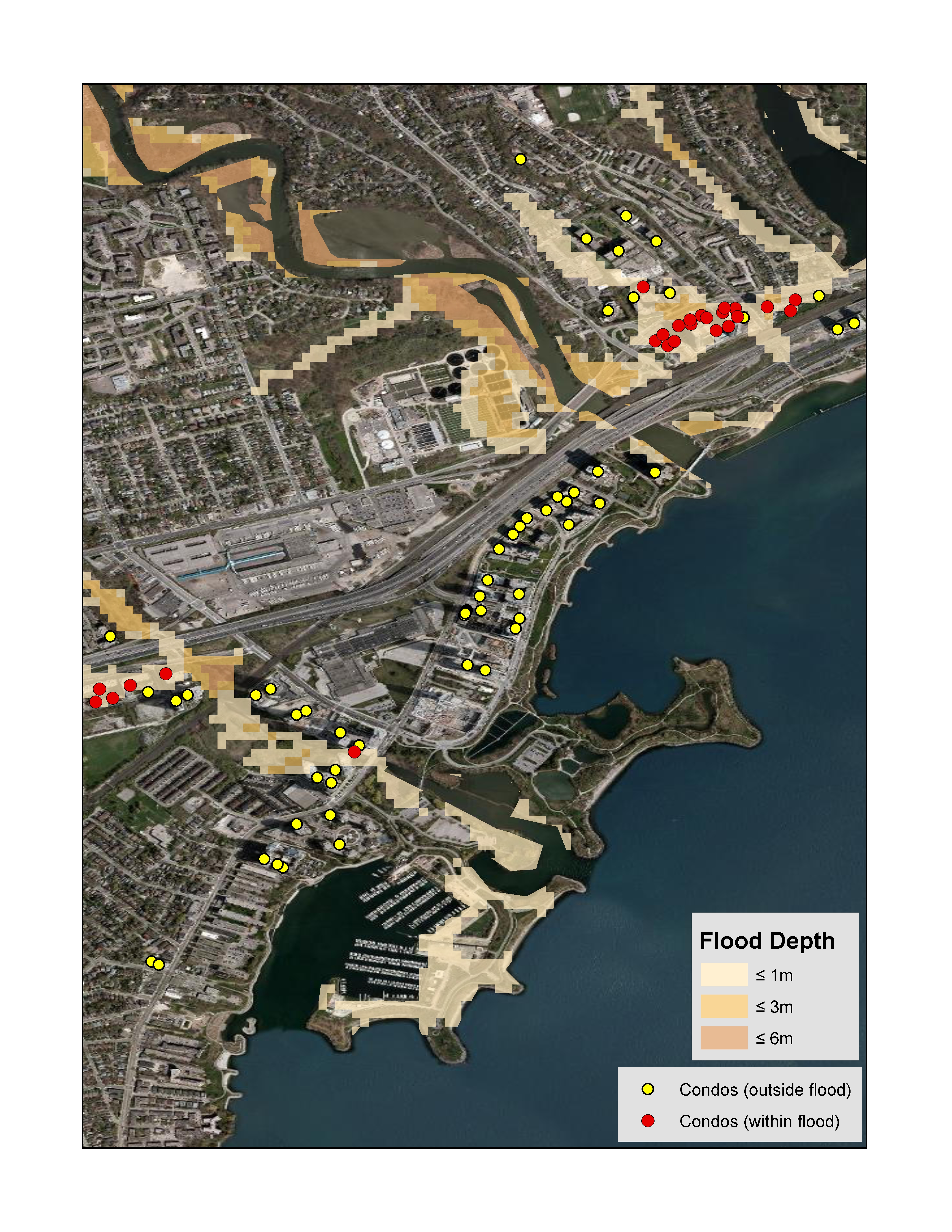
Toronto
Figure #1: Toronto, Ontario – Condos falling within the river flood hazard map for the 1/100 year return period.
Vancouver, BC
The flood risk analysis (using the 1/100 year return period) in Vancouver revealed that approx. 7.3% of all condo buildings may be impacted by surface water risk and approx. 3.2% of all condo buildings may be impacted by storm surge flood risk
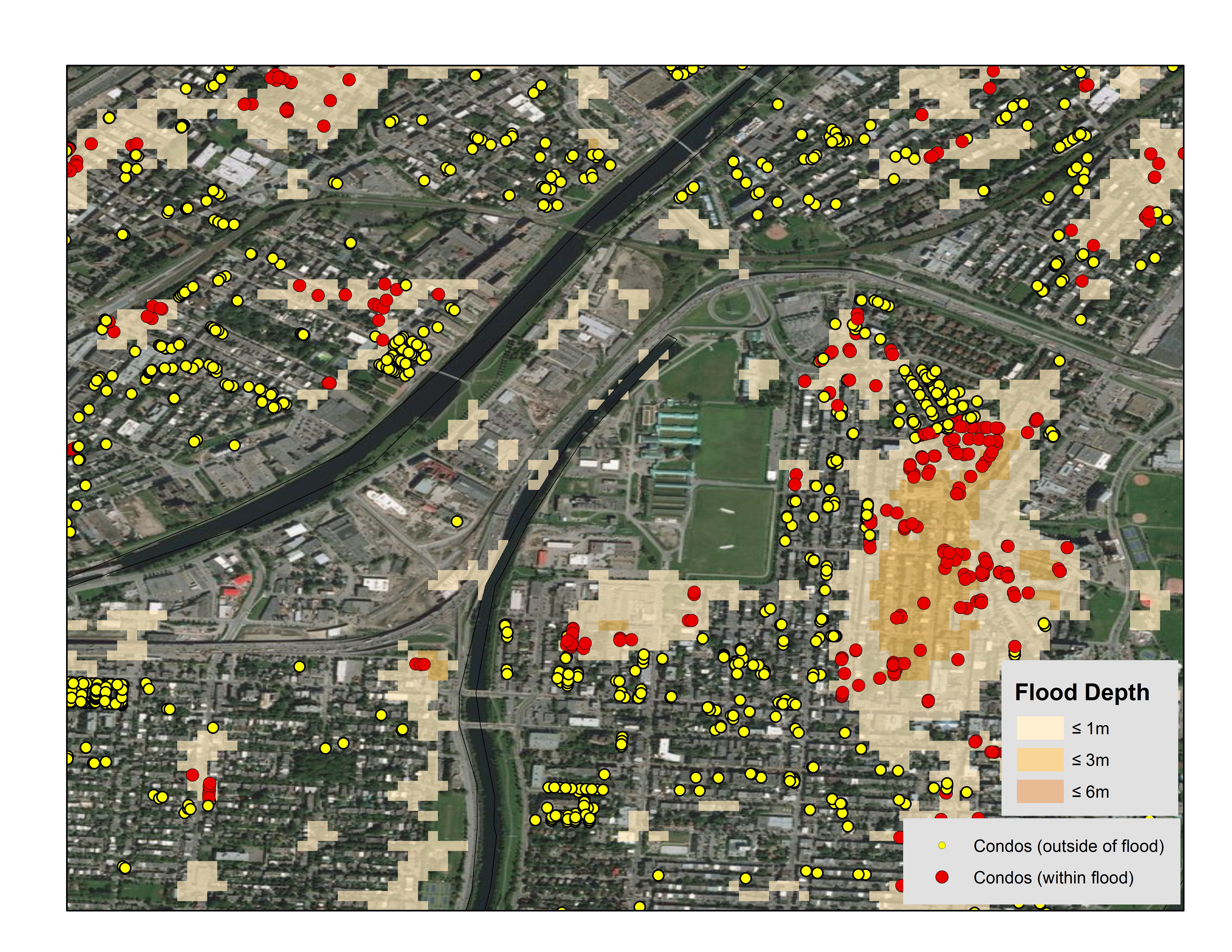
Figure 2: Vancouver, British Columbia – Condos falling within the surface water hazard map for the 1/100 year return period
Montreal, QC
The flood analysis (using the 1/100 year return period) in Toronto revealed that approx. 15.0% of all condo buildings may be impacted by river flood risk and approx. 11.4% of all condo buildings may be impacted by surface water flood risk.
Figure 3: Montreal, Quebec – Condos falling within the surface water hazard map for the 1/100 year return period
What does this mean to my business?
As per the Insurance Bureau of Canada (IBC) for flood perils, 20% of Canadian households could be qualified as high risk, and about 10% of those would be considered very high risk which equates to about 1.8 million households. Understanding the impact of natural disasters such as catastrophic flooding is a complex issue. Many customers are challenged with identifying and mitigating their total risk and exposure within their existing portfolio. Here are some additional areas for consideration that would benefit from this type of analysis:
The analysis conducted by DMTI Spatial using its platform Location Hub supports real-time flood risk analysis, portfolio accumulation risk analysis and the real-time visualization of the potential exposure to flood zones. This provides key data of importance to better forecast exposure and mitigate risk.
Contact us to learn more

Look for an integrated customizable solution that works with Regional Municipalities, Local Council Authority (LCA), Local Municipalities, or your agency’s framework. This means you are in complete control of what is shared and how feedback is received.
Make sure the platform provides intuitive and user-friendly access to data. In the past, data overload has been an issue. Employees would have to expend a lot of time and energy weeding out the useful information from the noise. Likewise, the public may be looking for specific information and be forced to comb through all the available data layers to obtain the information they seek.
Pick a platform built for all users. Avoid the scenario where one employee has to become expert at accessing the data or answering the same questions from multiple constituents. This way you can avoid frustration by constituents trying to find an answer and not finding a person who can help. With the right technology partner, there is no GIS expertise required to implement and tailor a solution.
Focus on a secure solution. The platform used should be secure and follow established encryption guidelines.
Make sure the platform is reliable so you can be assured of access when you need it to. Make sure the data is updated in real-time and that the updates are delivered seamlessly, ready for you to start using immediately.
Look for a platform that is easy to maintain. Data integration used to be a huge effort when it came to maintenance. Each agency or department was required to have dedicated servers to contain the data and run the platform. This allowed for greater likelihood of platform interruption if one of the servers went down. It also had a budgetary impact for additional staff and equipment needs to keep the platform running, during a time when every penny is counted and stretched as far as it could go. With the right platform, you can transfer the maintenance stability and costs to a single vendor so your agency can do what it does best.
No matter where your city is on the transition timeline to becoming a smart city, your use of this checklist is either a first step or a continuing step forward. If you have questions about how your city can get started or what role GIS technology can and should play in your progress, please get in touch. Your community and your fellow city employees will thank you!
Use this checklist to help your team learn what 6 characteristics to look for in a GIS platform.
Contact us to learn more.

Using Spatial Technology to Improve the Customer Experience in the Insurance Industry…While Increasing Profits
Customer experience in the insurance industry is a hot topic, and it’s easy to see why. A strong customer experience is the key to growth and profitability, requiring many companies to focus on differentiating their customer experience to stay ahead of the competition. However, despite the obvious benefits of cultivating happy customers, many insurance providers struggle with how to deliver a great customer experience and increase profits.
You must find ways to maintain the integrity of your business alongside ways to serve customers better – because if you don’t someone else will. In a 2016 letter to his shareholders, Amazon CEO Jeff Bezos explained that being customer-centric is about staying ahead of customers and developing new ways to keep them happy. Bezos says that if you shift your focus from trying to create great customer experiences, then you’re already on your way down.
Insurance providers are concerned that providing better customer experiences could conflict with the established rules and processes they’ve developed for risk selection and pricing. This certainly doesn’t have to be the case. The solution is using a spatial technology platform that supports and strengthens existing workflows while helping develop meaningful digital experiences for customers.
In today’s tech-enabled world, your customer’s digital experience plays a huge role in how they perceive your company. Your website is often a customer’s first touch-point with your company and will be the first time they assess if you can meet their needs. Studies show you’ve got less than 1 minute to convince website visitors whether or not they should try your product or service. In insurance, that translates to showing customers they can expect fair pricing and an efficient turnaround time.
That’s where your spatial technology platform comes in.
People expect online experiences to be simple and intuitive and they are accustomed to instantly accessing the information they want. In the insurance industry, providing a great customer experience means being able to quickly deliver information or a plan for coverage. Leveraging a spatial technology platform enables automation and self-service, making the process of generating insurance quotes and pricing simple, fast and efficient.
More and more insurance companies are experiencing the transformative effects of automation, including improved accuracy and efficiency. Data gathered by customer inputs can be automatically delivered into your underwriting process, and remain consistent with the risk selection and pricing models developed by your company’s actuarial/risk group. A well-defined process can easily interface with a spatial technology platform to automate inputs for calculation resulting in instant assessment and pricing.
Spatial technology platforms deliver location-based insights, including tools like geocoding, digital mapping, data analytics and visual dashboards, helping insurers use location intelligence throughout the policy lifecycle to deliver on client needs without sacrificing profitability. Using automated workflows, your spatial technology platform will geocode addresses in real time providing high precision coordinates, and automatically cross reference this data with the appropriate risk factors within your risk assessment models and pricing engine.
In addition to improving profitability by streamlining customer’s access to plans and policies, spatial data paired with customer information can also be used to assess additional plans that consumers may not realize they could benefit from, therefore offering ample opportunity for your company to cross-sell or upsell additional plans and features.
A strong spatial technology platform provides the location-based insights and analytics necessary to support underwriting, exposure management and claims. This data allows you to improve auditability with defined automated rules and quickly aggregate and visualize location information for more effective and accurate analysis when determining risk.
Real time location intelligence helps insurers quickly respond to policy applications, catastrophic events, and claims with greater accuracy. The ability to apply geographic coordinates (geocoding) to the property of interest offers insurers the ability to associate complex data sets with those coordinates, enabling deeper insights on concentration risk and exposure to hazards. This includes earthquakes, flooding, windstorms and more. These insights can better enable no-touch, low-touch adjudication processes, or provide better insights through visualization for exception handling or portfolio risk analysis.
Finally, the data on a strong spatial technology platform is continually updated to reflect the most current, precise location data, improving risk assessment to ensure accurate pricing.
When it comes to developing a great customer experience in the insurance industry, it’s important to keep things simple. Companies now have the tools to gather data on what customers want and need to keep them happy, loyal to your brand, and refer you to other potential customers. Using spatial technology, you can manage and monitor risk exposure in real time, with complete location data on one platform.
DMTI is the gold standard for GIS and location-based data in Canada, offering insurers scalable on-demand tools that support real time workflows. DMTI Spatial’s Location Hub® & UAID® is the only solution of its kind in Canada, and supports you company’s risk assessment process by delivering data visualization tools, and data delivery infrastructure to provide high-precision location accuracy.
Click here to find out how DMTI will help your insurance company experience greater growth and profitability.