Geofence and Location data

A Beginner’s Guide to Geofencing

Read how having millions of consumers walk around with tiny GPS chips in their pockets has opened up new realms of targeted marketing for businesses across the world

There has been a lot of chatter about geofencing in the advertising circles of late, and not without reason. From being tossed around as a ‘buzzword’, geofencing has thoroughly graduated to be the ‘go to’ technology in every marketer’s arsenal. Research firm, Markets and Markets is, in fact, convinced that geofencing market size will cross $1,825 million by 2022. But, what is this marketing technique all about and how does it work? This post tells it all.

What is Geofencing?

Geofencing refers to the creation of a unique virtual boundary or fence around a specific geographical area using technologies like GPS (Global Positioning System) and/or radio frequency identifiers such as WiFi devices and Bluetooth beacons. When someone enters this virtually-barricaded area, an action is triggered – usually in the form of a text message, email alert or app notification being pushed out.

So, if a latte discount coupon pops up on your phone every time you are about to approach a Starbucks outlet or Uber sends you a holler the moment you step out of the airport, you can be sure it is geofencing at work. The same technology fuels your smart home controls as well, letting the thermostat know when you are home/away and setting the temperature accordingly.

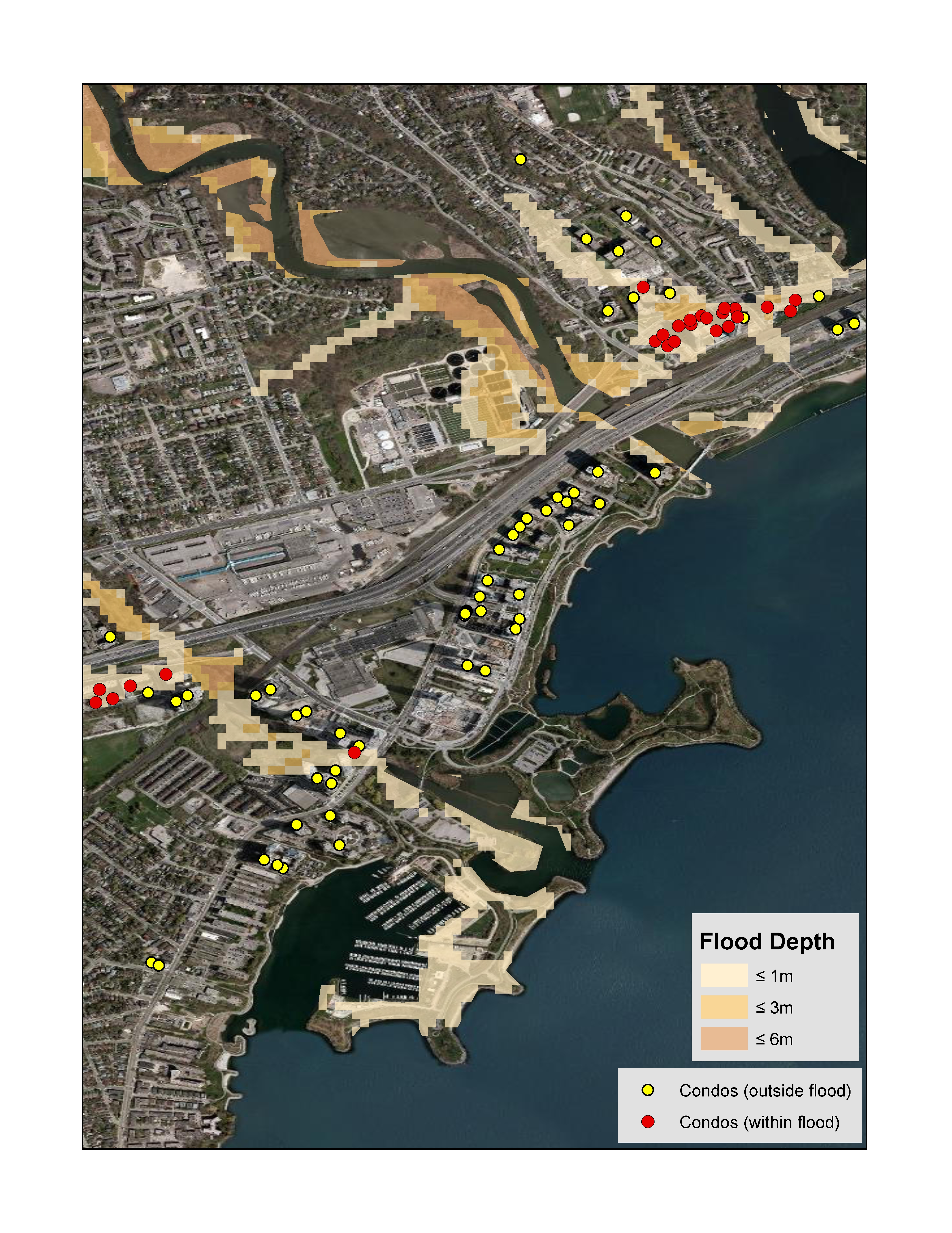
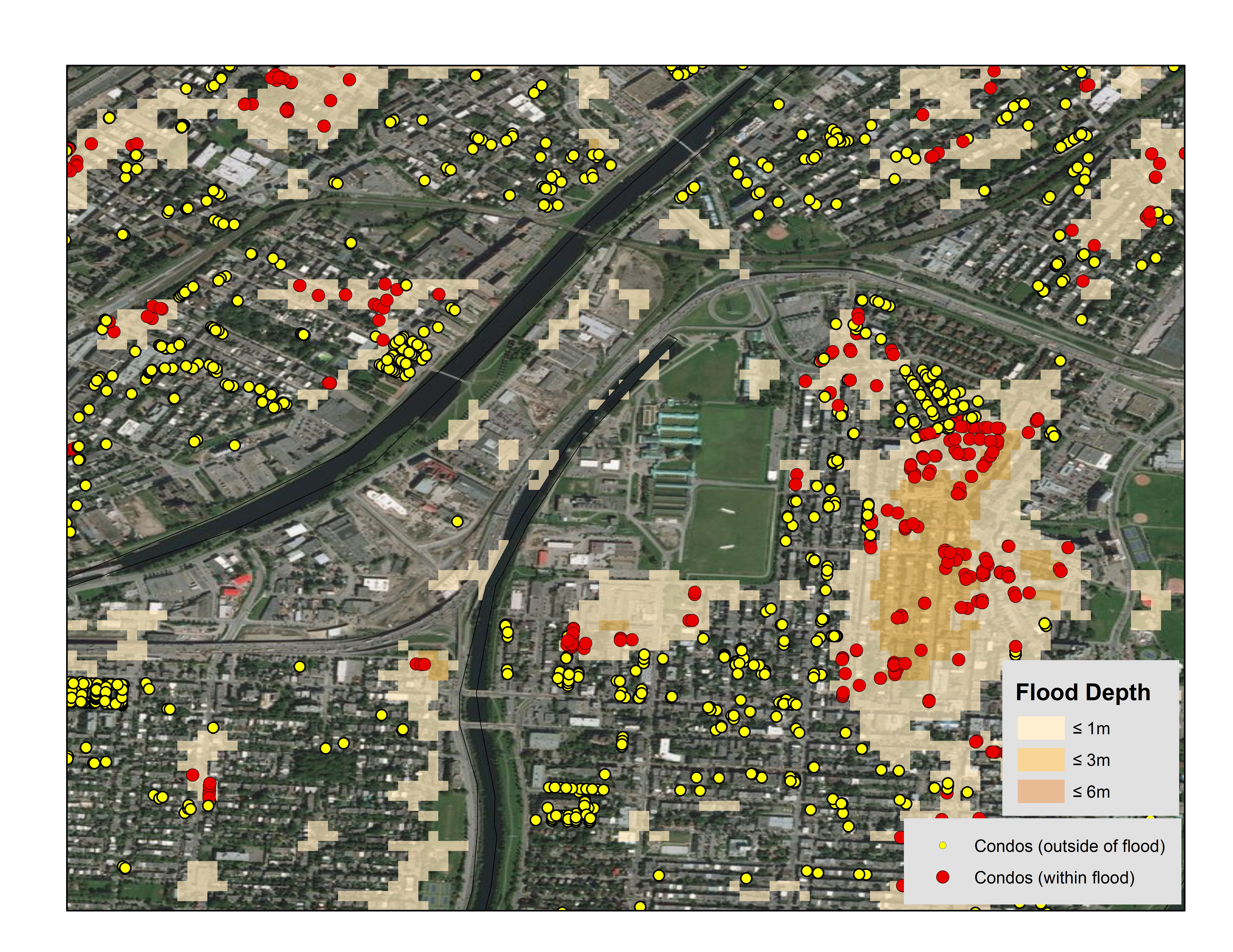
To be clear, there is no restriction on how big or wide a geofence can be. You can put an entire city under a geofence if you like, but that would not be very prudent. Geofencing is most effective when it is used to target smaller regions like streets or specific neighborhoods – especially when the aim is to drive more foot traffic to a brick-and-mortar store.

So, for example, if you would like to get more people to visit your store in a mall, make sure the walk time is not more three-four minutes from the place where they receive your notification. Similarly, for drivers, your outlet should not be more than a few blocks down the road.

This is why it is important to have access to a reliable location-based framework that can help you map existing customers in relation to your own stores or the location of your competitors. And if you have accurate datasets for addresses, you can easily identify potential customers located in the proximity of existing clientele as well. Done wisely, geofencing helps in:

  • Customer retention: Companies can keep their brand top-of-mind for customers and boost loyalty by sending promotions to people who are near their own outlets
  • Customer acquisition: Businesses can target people who are visiting a competitor’s store and offer them incentives to shop from their brand instead. This is also known as geo-conquesting
  • Crowd targeting: Many organizations like to put a geofence around mass events like concerts or fairs to target a large number of potential buyers in one go.

Examples of Successful Geofencing

Geofencing has been around for several years, but it wasn’t until the smartphone revolution swept over the world that this digital marketing tool truly could come into its own. Millions of consumers walking around with tiny GPS chips in their pockets have opened up new realms of targeted marketing for businesses across the world. Here’s a sample…

  • Whole Foods: One of the most successful examples of geofencing that everyone should know about is that of American grocery store brand Whole Foods. By using a lethal combination of geofencing its own stores as well as its competitors’ stores, the supermarket chain was able to realize a 4.69% post-click conversion rate, which is more than three times the industry average.
  • Taco Bell: The fast food chain’s geofence targets people under 30 in a 2-mile-wide area around its stores. By sending out feelers to hungry customers that they can place their order on the Taco Bell app and pick up hot food without any wait time has resonated with the generation that demands instant gratification.
  • BMW: The automaker’s geofencing plan focuses more on customer service than grabbing the attention of a prospective buyer. BMW leverages geofencing technologies in its Trackster services which keep a tab on the cars’ geographical position. If a vehicle moves out of its predefined geofence without the use of its keys, the car’s owner is notified.
  • North Face: The outdoor sports gear company uses geofencing in conjunction with weather-based information. North Face reports receiving a 79% surge in store visits from customers who got the weather-based geofencing alerts. Of these, 65% customers ended up making purchases.

Truly, geofencing is a bridge that connects the physical world with the digital world. Not only does it make your messaging much more relevant to your customers, it also ensures that you get the biggest bang for your advertising buck. Several businesses world over have already discovered the transformation geofencing can bring to their digital marketing strategy, and yours could be the next.

Contact us today to learn how DMTI can help enable your Geofencing initiatives.


Additional Reading:  

Flood Data and Location Intelligence

Leveraging Flood Analysis to Mitigate Risk

Condo popularity is on the rise and for those financing the properties, whether it be a reputable financial institution or the bank of mom and Dad, is your investment protected? What happens in the event of a flood and are you asking all of the right questions before investing? For example, are you investing in properties that are a high risk to flood? With help from DMTI, we’re able to take a closer look on a few regions to understand your exposure.

What risk does flood pose in Canada?

Floods are the most frequently occurring natural hazard in Canada. According to the Institute for Catastrophic Loss Reduction (ICLR), the Canadian Disaster Database indicates that 241 flood disasters have occurred in Canada between the years 1900 and 2005, almost five times as many as the next most common disaster (wildfire). Over the past few decades, urban flooding has been a growing problem, resulting in more than $20 billion in flood damage between 2003 and 2012, according to the federal government.

What is the risk of flood peril to condos in Canada?

In order to provide answers to this question, a condominium database for Canada was created by Teranet and DMTI Spatial combined with flood hazard maps highlighting areas that could be impacted by river flood (where the water rises over its banks), surface water (where water will pool due to elevation differences) and storm surge (coastal flooding). Three key markets were focused on as part of this analysis: Toronto, Vancouver and Montreal.

Toronto, ON

The flood risk analysis (using 1/100 year return period) for Toronto revealed that approx. 1.2% of all condo buildings may be impacted by river flood risk and approx. 5.9% of all condo buildings may be impacted by surface water flood risk.

Toronto

Toronto

Figure #1: Toronto, Ontario – Condos falling within the river flood hazard map for the 1/100 year return period.

Vancouver, BC

The flood risk analysis (using the 1/100 year return period) in Vancouver revealed that approx. 7.3% of all condo buildings may be impacted by surface water risk and approx. 3.2% of all condo buildings may be impacted by storm surge flood risk

Figure 2: Vancouver, British Columbia – Condos falling within the surface water hazard map for the 1/100 year return period

Montreal, QC

The flood analysis (using the 1/100 year return period) in Toronto revealed that approx. 15.0% of all condo buildings may be impacted by river flood risk and approx. 11.4% of all condo buildings may be impacted by surface water flood risk.

Figure 3: Montreal, Quebec – Condos falling within the surface water hazard map for the 1/100 year return period

What does this mean to my business?

As per the Insurance Bureau of Canada (IBC) for flood perils, 20% of Canadian households could be qualified as high risk, and about 10% of those would be considered very high risk which equates to about 1.8 million households. Understanding the impact of natural disasters such as catastrophic flooding is a complex issue. Many customers are challenged with identifying and mitigating their total risk and exposure within their existing portfolio. Here are some additional areas for consideration that would benefit from this type of analysis:

  • Risk Mitigation: Enhance real-time mortgage adjudication processes, speed time to decision and reduce manual intervention with enhanced insight into the precise location of the property as it relates to a flood zone.
  • Risk Analysis: Validate capital adequacy requirements and better understand and reduce exposure by being able to assess the total accumulated risk to a portfolio as it relates to proximity within flood plains.
  • Site Planning: Enhance infrastructure and site planning analysis by understanding the potential risk of flood before deployment.

The analysis conducted by DMTI Spatial using its platform Location Hub supports real-time flood risk analysis, portfolio accumulation risk analysis and the real-time visualization of the potential exposure to flood zones. This provides key data of importance to better forecast exposure and mitigate risk.

Contact us to learn more

location data

Location intelligence paving the road to shared mobility in Canada

Innovative startups and governments are filling the gaps in the existing transportation infrastructure using historical and real-time location data

On the second-largest country on earth, 80% of the commuters use their own vehicles to get to work. Which means that in the largest metropolitan areas of Canada, travel time for car drivers could become excruciatingly long – a fact that has not escaped the attention of politicians either.

There is an increasing awareness, especially at the levels of municipal governance, that a cultural shift is required. The burgeoning population of Canadian cities can no longer suffice with transit operators alone. The government needs to actively partner with the private sector to become a mobility manager and repurpose the transit infrastructure in a more resourceful manner. This mindfulness is leading to the rise of shared mobility in Canada.

What is shared mobility?

Shared mobility can be defined as the shared use of transportation modes like vehicles, bikes, etc., by people. But more than a means of transportation, shared mobility refers to a transit strategy. There are various types of shared mobility services available to the users today – car-sharing, ride-hailing, shuttles, carpooling, bike-sharing, etc.

Mobility researchers believe that a single shared vehicle is capable of taking up to 11 private cars off the roads by way of a decrease in the demand for new vehicles as well as shared mobility users selling off their existing vehicles. As of 2017, there were 3,300 car-sharing vehicles operating in the city of Vancouver alone. And while that hearty number may partly be a result of ride-hailing services being illegal in the British Columbian city, a recent Vancity survey has revealed that citizens opt for car-sharing services because of convenience (95%) and saving money (62%), followed closely by concern for the environment (58%).
But, what role does location intelligence play in this ecosystem? Let’s find out…

Location intelligence and shared mobility

One of the basic requisites for any shared mobility service is location-awareness. Think about it: What is the single most important thing you need to do for requesting an Uber or a Maven or a BlaBlaCar? You need to enable location services on your smartphone or mobile tablet; and the tiny GPS chip embedded in your device takes care of the rest.

Location intelligence has made shared mobility a $40 billion industry, according to a report commissioned by Google. The report says, “Google’s digital maps already provide the option to book ridesharing services, such as Uber, Cabify, Ola and Grab, while allowing users to directly compare the cost and travel time of shared rides with other transport options. In addition, online maps have also begun to encourage people to use buses and trains instead of cars.”

Digital maps are at the very core of urban mobility. The advances in location awareness have made digital maps highly accurate and reliable. Modern mapping companies not only update their data frequently, they also ensure that they hide complex spatial technologies under the hood and provide the users with a clean and easy-to-use software or tools. This has led to an increase in the adoption of location-based services and applications even among those organizations that do not have trained location professionals on their employ.

The road ahead for shared mobility

It is no secret that several companies like Lyft, Cabify, Grab, Ola, EasyTaxi, etc., have built their fortunes on the wings of spatial awareness. But, the use of location technologies is not limited to just acting as a beacon that leads a vehicle to a user. Innovative organizations – and even governments, for that matter – are filling the gaps in the existing transportation infrastructure using historical and real-time location data in novel ways.

In the United Kingdom, public transit tracking startup Citymapper studied 6 years of location data to determine London needed a nighttime bus service. In 2017, it started that bus service, which has now graduated to an eight-seater taxi-bus hybrid facility. Meanwhile, Coord – the city-planning platform of Google’s Sidewalk Labs – is making bike-sharing simpler by helping to integrate real-time transit data into online navigation software. Closer to home, the town of Innisfil, Ontario, has partnered with Uber to offer a new service which would act as an alternative to traditional public transport.

Shared mobility is constantly evolving, with some studies forecasting its global market size to grow to $200 billion by 2024. With more innovations from the private sector and greater collaborations between the public and the private sector, Canada can easily position itself to benefit from the ultimate success of this industry.

For more information on how DMTI Spatial, a Digital Map Products company, can help scale your location-aware application, contact us today!

Location Intelligence Marketing

Leverage Location Intelligence for Precision-Targeted Direct Mail Campaigns

By Robert Szyngiel, DMTI Spatial

Direct marketers know that the days of “spray and pray” with flyers and other direct marketing initiatives are over. Effective marketing requires highly targeted campaigns directed to very specific customer segments. However, despite the best efforts of an organization to build a valuable database of customers and prospects, address data is often flawed and therefore it becomes an Achilles heel undermining the success of direct marketing campaigns.

There are many factors impacting the accuracy of data, for instance each year more than 10 percent of Canadian addresses are impacted by changes to postal codes or street names.   In addition to external factors such as address changes, many internal reasons including sloppy data entry,  systems integrations and merged data due to acquisitions can make location data in customer and prospect databases inaccurate. The reality is that customer and prospect address data isn’t static and is vulnerable to inaccuracies, which poses a significant problem for direct marketers who rely on the accuracy of their organization’s databases to achieve the best return on investment for their campaigns.

Using location intelligence to improve and enhance database information

Fortunately, cloud-based solutions are available that can automatically consolidate, cleanse and validate address data, as well as remove duplicate records and assign unique geocodes to locations in a customer and prospect database. Using high-quality cleansing tools can improve database quality by as much as 30 percent and ensure that mail campaigns are targeted to the right people. Additionally, location intelligence can be used to identify new prospects that were not contained in a company’s database previously.

Once accuracy is achieved for address data, it is possible for a company to move to the next level by integrating additional valuable location information that will be helpful in segmenting customers and prospects. This location information can include data such as age, gender, family size, income, dwelling type, drive time, drive distances and many other variables that can improve the direct marketer’s decision-making process. For example, if a company is marketing replacement windows, location data can be used to eliminate anyone living in an apartment from a mailing list. Similarly, if a high end retailer is opening a new store, location intelligence can help identify affluent residents to target within a certain driving distance from the store.

Using additional attributes of this kind enables an organization to understand which data points and geographic areas are associated with the most sales so that it can tailor marketing campaigns and easily refine programs to ensure that the right people are receiving the right messages. Moreover, some cloud-based location intelligence solutions include easy-to-use visualization tools that make it possible for business users to view location information on a map for greater insight, better collaboration and more precise analysis. Database data can dynamically identify clusters of relevant customers and create boundaries that are more relevant than what can be achieved using census and postal boundaries.

One utility’s experience

A case in point that illustrates the value of location intelligence for direct marketing is the experience of a major Canadian natural gas storage, transmission and distribution company that wanted to expand a home weatherization conservation program. In the past, the program had only been offered to customers living in subsidized housing, leaving a significant segment of its potentially eligible customer base with minimal access to the program benefits. With more than one million customers, the challenge was to only promote the program to the customers most likely to be eligible for it. The utility estimated that only 14 percent of its customers would be eligible but did not know where these customers were located geographically.

Turning to a location intelligence solution, the utility was able to visualize existing customer addresses and cross-reference those addresses with house size and house age range characteristics. By tying all this information together, the utility was able to pinpoint the exact neighborhoods in which to promote the program, resulting in a 400 percent increase in the program uptake rate over previous direct marketing attempts to expand the program.

In today’s big data environment, there is a massive amount of information available that is relevant to buyer behavior. Location is tied to almost all of that information and can serve as the backbone for strategic business planning, ensuring that as marketing campaigns are designed they leverage accurate data that will make them more cost-effective and targeted to achieve the desired results.

Contact Us to learn more


Robert Szyngiel leads Product Management at DMTI Spatial, a Digital Map Products company. He provides strategy and guidance to the data and software teams to assemble innovative SaaS solutions that leverage DMTI Spatial’s 20-plus years of location intelligence intellectual property. For more information on DMTI Spatial, visit www.dmtispatial.com, and for information on Digital Map Products, visit www.digmap.com.


Additional Reading:


Smarty City and Location Data

6 Characteristics Smart Cities Should Look for in a GIS Platform

  1. Customization

    Look for an integrated customizable solution that works with Regional Municipalities, Local Council Authority (LCA), Local Municipalities, or your agency’s framework. This means you are in complete control of what is shared and how feedback is received.

  2. Relevant Information and Usability

    Make sure the platform provides intuitive and user-friendly access to data. In the past, data overload has been an issue. Employees would have to expend a lot of time and energy weeding out the useful information from the noise. Likewise, the public may be looking for specific information and be forced to comb through all the available data layers to obtain the information they seek.

  3. Improved Productivity

    Pick a platform built for all users. Avoid the scenario where one employee has to become expert at accessing the data or answering the same questions from multiple constituents. This way you can avoid frustration by constituents trying to find an answer and not finding a person who can help. With the right technology partner, there is no GIS expertise required to implement and tailor a solution.

  4. Security

    Focus on a secure solution. The platform used should be secure and follow established encryption guidelines.

  5. Reliability

    Make sure the platform is reliable so you can be assured of access when you need it to. Make sure the data is updated in real-time and that the updates are delivered seamlessly, ready for you to start using immediately.

  6. Maintenance

    Look for a platform that is easy to maintain. Data integration used to be a huge effort when it came to maintenance. Each agency or department was required to have dedicated servers to contain the data and run the platform. This allowed for greater likelihood of platform interruption if one of the servers went down. It also had a budgetary impact for additional staff and equipment needs to keep the platform running, during a time when every penny is counted and stretched as far as it could go. With the right platform, you can transfer the maintenance stability and costs to a single vendor so your agency can do what it does best.

No matter where your city is on the transition timeline to becoming a smart city, your use of this checklist is either a first step or a continuing step forward. If you have questions about how your city can get started or what role GIS technology can and should play in your progress, please get in touch. Your community and your fellow city employees will thank you!

Use this checklist to help your team learn what 6 characteristics to look for in a GIS platform.

Contact us to learn more.

Location Data and the Telecom Industry

Top 5 ways the Telecom sector is leveraging Location Data

Read to know why 70% of telecom companies are convinced that accurate location data is critical to their success

A telecom business has to face a range of burning questions on a regular basis: Where are my customers? Where is my crew needed the most? Where do I need to expand capacity? Where is my network lacking quality? Each of these questions has a foundation in spatial information.

For an industry as competitive as telecommunications, understanding relationships, trends, and patterns in a quick and efficient way is imperative to keep up with the evolving market dynamics. Location data helps telecom operators to visualize the myriad layers of data in a manner which is easy to understand and interpret. But even more importantly, it helps unlock pertinent insights previously not available to the business. So, it’s not surprising that the 2018 Location Intelligence Market Study by Dresner Advisory Services pegs location data as a key success factor for 70% of telecom companies.

Let’s discuss some of the most profitable ways in which the telecom sector is leveraging location data…

1.  Market Segmentation

Location data is the underpinning of all market segmentation activities like identifying high-revenue areas, segregating customers on the basis of their demography and buying behaviour, ascertaining where new building projects are coming up, or even undertaking a competitor analysis. Prudent telecom operators are using location data to boost their intelligence with customer profiling and determine the potential of the market correctly. This further allows them to determine where new capital investment needs to be allocated and where marketing budgets should be channeled for maximum impact.

2.  Network Analysis

Using accurate location data gives operators and crew instant access to customer details, enabling them to map signal quality information with their user base and identify where the signal strength is good or poor. Being able to visualize assets geographically also allows for better monitoring of the network and expedition of maintenance and repairs. And when it comes to making inroads into an already competitive market, precise location data helps telecom companies to identify new market opportunities in the proximity of their assets and expand network capacity in a cost-effective manner. Which brings us to the next point in our list…

3.  Capacity Planning

To plan and manage their capacity judiciously, telecom companies not only need to be able to map their current user base properly, they should be able to locate the pockets of future growth meticulously. Using location data, companies can zero in on new prospects by leveraging insights into current profitable customers to look for similar prospects. Here, the intelligence derived through market segmentation activities also comes into play. Location data analytics provide a solid decision-support ground for capital investments.

4.  Serviceability

The importance of providing a definitive and timely service cost assessment for new customers is not lost on progressive telco businesses. Accurate address information gives the sales team the confidence to upsell products without worrying about the availability of those services. When it comes to analyzing and tracking the serviceability for commercial accounts, telcos can easily map location information against serviceability and make sure a new customer opportunity does not turn into a bad customer service problem. Businesses can even plan to increase serviceability based on the competitive insights derived from authentic location data.

5. Customer Service

Effective customer relationship management gives a much-needed competitive edge to telecom companies. Having a unique address identifier  for each customer can eliminate communication errors and boost the speed and quality of customer handling. By resolving user queries and complaints in a timely manner, operators can improve the relationship between the company and the customer, thereby reducing the chance of a customer jumping to another provider (churning). They can also make significant cost savings by reducing the need for return visits by the field crew.

In a nutshell, location data is a strategic planning tool the telecommunications industry can use to enhance its capabilities, reduce errors, and carry out processes more accurately. Forward-thinking telcos are already using location data to improve market penetration and enhance their network design and coverage. To know more about how your telecom business can leverage location data for better operational efficiency and customer satisfaction, contact us.

Additional Reading:


Customer Experience

How Spatial Technology is Transforming Customer Experiences in the Insurance Industry

Using Spatial Technology to Improve the Customer Experience in the Insurance Industry…While Increasing Profits

Customer experience in the insurance industry is a hot topic, and it’s easy to see why. A strong customer experience is the key to growth and profitability, requiring many companies to focus on differentiating their customer experience to stay ahead of the competition. However, despite the obvious benefits of cultivating happy customers, many insurance providers struggle with how to deliver a great customer experience and increase profits.

You must find ways to maintain the integrity of your business alongside ways to serve customers better – because if you don’t someone else will. In a 2016 letter to his shareholders, Amazon CEO Jeff Bezos explained that being customer-centric is about staying ahead of customers and developing new ways to keep them happy. Bezos says that if you shift your focus from trying to create great customer experiences, then you’re already on your way down.

Insurance providers are concerned that providing better customer experiences could conflict with the established rules and processes they’ve developed for risk selection and pricing. This certainly doesn’t have to be the case. The solution is using a spatial technology platform that supports and strengthens existing workflows while helping develop meaningful digital experiences for customers.

Digital Customer Experience in the Insurance Industry

In today’s tech-enabled world, your customer’s digital experience plays a huge role in how they perceive your company. Your website is often a customer’s first touch-point with your company and will be the first time they assess if you can meet their needs. Studies show you’ve got less than 1 minute to convince website visitors whether or not they should try your product or service. In insurance, that translates to showing customers they can expect fair pricing and an efficient turnaround time.

That’s where your spatial technology platform comes in.

Use Spatial Technology to Deliver What Customers Want

People expect online experiences to be simple and intuitive and they are accustomed to instantly accessing the information they want. In the insurance industry, providing a great customer experience means being able to quickly deliver information or a plan for coverage. Leveraging a spatial technology platform enables automation and self-service, making the process of generating insurance quotes and pricing simple, fast and efficient.

More and more insurance companies are experiencing the transformative effects of automation, including improved accuracy and efficiency. Data gathered by customer inputs can be automatically delivered into your underwriting process, and remain consistent with the risk selection and pricing models developed by your company’s actuarial/risk group. A well-defined process can easily interface with a spatial technology platform to automate inputs for calculation resulting in instant assessment and pricing.

Spatial technology platforms deliver location-based insights, including tools like geocoding, digital mapping, data analytics and visual dashboards, helping insurers use location intelligence throughout the policy lifecycle to deliver on client needs without sacrificing profitability. Using automated workflows, your spatial technology platform will geocode addresses in real time providing high precision coordinates, and automatically cross reference this data with the appropriate risk factors within your risk assessment models and pricing engine.

In addition to improving profitability by streamlining customer’s access to plans and policies, spatial data paired with customer information can also be used to assess additional plans that consumers may not realize they could benefit from, therefore offering ample opportunity for your company to cross-sell or upsell additional plans and features.

Using Spatial Intelligence to Improve Risk Assessment and Pricing

A strong spatial technology platform provides the location-based insights and analytics necessary to support underwriting, exposure management and claims. This data allows you to improve auditability with defined automated rules and quickly aggregate and visualize location information for more effective and accurate analysis when determining risk.

Real time location intelligence helps insurers quickly respond to policy applications, catastrophic events, and claims with greater accuracy. The ability to apply geographic coordinates (geocoding) to the property of interest offers insurers the ability to associate complex data sets with those coordinates, enabling deeper insights on concentration risk and exposure to hazards. This includes earthquakes, flooding, windstorms and more. These insights can better enable no-touch, low-touch adjudication processes, or provide better insights through visualization for exception handling or portfolio risk analysis.

Finally, the data on a strong spatial technology platform is continually updated to reflect the most current, precise location data, improving risk assessment to ensure accurate pricing.

DMTI Helps Insurance Companies Improve the Customer Experience

When it comes to developing a great customer experience in the insurance industry, it’s important to keep things simple. Companies now have the tools to gather data on what customers want and need to keep them happy, loyal to your brand, and refer you to other potential customers. Using spatial technology, you can manage and monitor risk exposure in real time, with complete location data on one platform.

DMTI is the gold standard for GIS and location-based data in Canada, offering insurers scalable on-demand tools that support real time workflows. DMTI Spatial’s Location Hub® & UAID® is the only solution of its kind in Canada, and supports you company’s risk assessment process by delivering data visualization tools, and data delivery infrastructure to provide high-precision location accuracy.

Click here to find out how DMTI will help your insurance company experience greater growth and profitability.

Underwriters DMTI Spatial CanMap Canadian GIS Data

Top 3 Ways Location Intelligence Empowers Underwriters

Today, modern location intelligence solutions are transforming the underwriting process. They give front line underwriters the ability to quickly and intuitively understand the exposures associated with one address – or an entire portfolio. Geospatial analysis has evolved from a back-office, ‘after the-fact’ function to a leading role in real-time underwriting decisions. Below are the top 3 ways Location Intelligence empowers Underwriting.

1) Individual Risk Assessment and Pricing 

True location intelligence solutions allows underwriters to more accurately assess risk at the individual property level, resulting in higher quality underwriting, more profitable business and cost savings through reduced claims.

Proper risk assessment starts at the point of sale. In the case of personal and commercial properties, that involves the validation and cleansing of addresses. Location intelligence solutions allow insurers to quickly validate the accuracy of new addresses or addresses currently on file for existing policyholders.

2) Risk Accumulation and Portfolio Management 

Accumulation or concentration of risk is an ongoing concern for insurance companies. An accumulation of risk occurs when a portfolio of business contains a concentration of risks that might give rise to exceptionally large losses from a single event. Such an accumulation might occur by location (property insurance) or occupation (employers’ liability insurance), for example.

Insurance underwriters require real-time visibility into their policy accumulations, perils risk data and claims history across their book of business. With an aggregated view of risk (perils and accumulations), underwriters can better manage their overall exposure across their entire portfolio.

Location intelligence solutions offer an accumulation and perils management tool to analyze various risk levels against individual addresses, street levels and postal codes to produce hazard ratings. This means underwriters can make decisions using up to-date data, such as flood or earthquake risk, contaminated land or proximity to potential risk sites, such as gas or propane storage facilities

3)  Segmentation 

A powerful result of location intelligence technology for underwriters is segmentation. Instead of looking at risks on a “blanket” basis, they have new tools to slice individual exposures by specific rooftop locations. In the example of a flood-prone region, insurers can identify which specific properties are at risk, instead of relying on broad postal code or FSA boundaries.

By assessing risk at the property level, insurers have the ability to underwrite business they may have previously declined, based on an inaccurate assessment of the risk location. With a better understanding of geographical risk (peril and accumulations) insurers can be more aggressive with rates in low-risk areas. Underwriters can identify under-exposed areas and target those areas with marketing efforts and competitive premium. Using a location intelligence capability, the insurer can hone in on a given region’s hot and cold spots

Conclusion 

Location-based technology has become an invaluable strategic tool to many leading insurers. Precise mapping and geocoding allow underwriters to quickly access information, recognize patterns and drill down into data for detailed analysis and sound decision-making. The real danger for those carriers not adopting location intelligence is adverse selection – the writing of poor risks without accurate or detailed information.

Understanding where a property is in relation to risk elements is a key decision affecting an insurance carrier’s profitability. Using location intelligence is a simple solution to a complex, real-world problem for the insurance industry. Insurers depend on geographic and demographic information to assess underwriting risk, develop appropriate pricing models, match coverage, expand markets, serve existing customers and develop new or niche business

To learn more download our Property & Casualty Insurance: Getting Risk Right White Paper

IoT and Location Intelligence

5 Industries Being Transformed by IoT and Location Intelligence

Read to learn how the fusion of location data with the Internet of Things (IoT) is making organizations smarter and more efficient across industries

So many devices around us have steadily gotten connected to the Internet that we hardly even notice how extensive the Internet of Things (IoT) ecosystem has become. Our computers and smartphones may be the most obvious IoT players, but today, everything from household items to manufacturing machinery has been embedded with sensors which are generating and streaming data without any kind of human intervention.

Given this pace of proliferation, Gartner says we should expect to see more than 20 billion Internet-connected devices by 2020. And McKinsey maintains that IoT applications could have a global economic impact to the tune of $3.9 trillion to $11.1 trillion per year by 2025. These incredible figures start to sound all too plausible when you look at the developments closer home.

According to IDC Canada, over 45% of Canadian organizations today have dipped their toes in the IoT pool and the IoT market in the Great White North alone is predicted to reach a value of $13.5 billion by 2019. When you consider how IoT is giving businesses access to knowledge they could never tap into before, the optimism for IoT applications gets more than justified.

IoT sensors generate a massive amount of data every day. To both increase revenue and decrease costs, all companies need to do is know how to extract actionable insights from the information at their disposal. Many industries have discovered that the best way to do that is to tie disparate information streams together using an easy-to-recognize context called location.

By using precise location data, organizations can easily visualize what is happening where. And by analyzing historical data bound by spatial awareness, they can map trends and use these insights to optimize business processes.

Let’s dig a little deeper into how various industries are becoming smarter and more efficient by fusing IoT with location intelligence:

Smart Cities

Urban analytics is an essential component of smart city development. IoT and location intelligence are allowing governments and municipal agencies to quickly gather regional insights to identify inefficiencies as well as environmental impacts and risks. For instance, smart sensors on wheels can not only identify most congested areas, they can also provide a telling picture of pollution hotspots. Further, IoT and location intelligence are also creating ladders of opportunities for businesses. For example, the Canadian city of Mississauga publishes its real-time bus locations as a live open data set. A gallery can easily use that information to tell a commuter about an art exhibit they could visit at the next stop.

Supply Chain and Logistics

The marriage of IoT with location intelligence is bringing greater levels of transparency and efficiency in the supply chain, and changing the playing field for organizations that deal with logistics. Embedding tags in cargos is leading to an unprecedented ease in asset tracking and tracing – both during in-freight operations and at the time of inventory management in a warehouse. Distribution centres are also able to manage their yards more effectively by providing up-to-the-minute directions to truckers based on the type of goods they are carrying. And businesses even have an opportunity to provide early intervention in case an asset goes missing or is out-of-place.

Consumer Retail

A study undertaken by Deloitte and the Retail Council of Canada has found that retailers are using smartphone-based traffic analysis to understand the foot traffic outside and inside stores during different times of the day. This data is helping retailers to implement strategies to grow in-store traffic at preferred times. But that’s not the only way how location intelligence and IoT are transforming consumer retail in Canada. Retailers are also using these technologies to execute everything from offering in-store navigation to identifying profitable locations for new stores.

Insurance Companies

According to PWC Canada, 63% of insurance CEOs are convinced that IoT will be strategically important for their organization. And location intelligence is a natural fit for this bundle. Sensor data backed by spatial awareness can give insurance providers first-hand information about what happened, improving their ability to proactively address claims. Insurance companies can also use the location-backed data to improve their risk rating, detect fraud, and improve customer loyalty. For instance, a car insurance provider can offer discounts on premiums to its customers based on their real-time driving data.

Energy and Utilities

Providing reliable, high-quality and uninterrupted service requires a great amount of visibility and control across the entire utility network. IoT and location intelligence make that possible in ways more than one. Peterborough Utilities Group in Ontario, Canada efficiently manages outages and voltage discrepancies in its distribution network by using IoT to capture multiple data points like temperature, board status, etc., every few minutes from its metering points. Meanwhile, BC Hydro, the chief electric utility for British Columbia, has found that it can restore power faster and isolate faults to the smallest possible area leveraging an IoT-based smart grid system.

Clearly, location awareness is indispensable for an effective IoT network. Location intelligence can provide both context and relevance to an organization’s decisions supported by sensor data and open up a wealth of opportunities for smarter growth.

To know more about how you can benefit from adding precise location data to your IoT setup, contact us.

Additional Reading: