Marketing and Location Intelligence

3 Ways Brick-and-Mortar Stores Are Using Location Intelligence

Many brick-and-mortar stores suffered financial losses in recent years due to the ease and efficiency of online shopping. While some businesses view the rise of online shopping as the ultimate enemy, innovative businesses are using the shift in consumer shopping habits as an opportunity to develop new and exciting incentives for driving traffic into their stores.

Omnichannel marketing is a powerful way for brick-and-mortar businesses to leverage multiple marketing channels to drive greater brand awareness, in-store traffic, and sales. Location based insights are at the core of this, helping businesses illustrate their unique value proposition and provide fun and fresh ways for customers to engage with their brand.

Here’s how successful brick-and-mortar stores drive foot traffic and generate sales using location intelligence:

Leverage Geofencing:

  • Gain competitive insights: Conduct trade area analysis by placing geofences around competitors to reveal how often your customers visit them. You can pair this with tracking competitor deals and incentives to gain knowledge on how to steer customers back to you…or keep them from visiting competitors in the first place.
  • In-store incentives: If your customers allow notifications, you can deliver limited time pop-up ads every time they are within a certain distance from your store, or an extra deal when they are about to leave your store.  Input customer data: Location intelligence platforms allow you to input customer information, useful for developing targeted marketing campaigns. This includes precise mailing addresses and detailed demographic information.

Precise direct mail campaigns:

Studies show that direct mail ROI is strong when marketers use omnichannel marketing methods to deliver a seamless and personalized customer experience to match lifestyles with customer buying trends. Pairing digital intelligence with direct mail can produce powerful results. Location technology delivers detailed demographic information along with accurate postal codes so that you are delivering the right message to the right people rather than wasting time and money on consumers that are unlikely to be interested in your product or service.

Location-based insights for site selection:

For brick and-mortar stores looking to open a new shop or to relocate, location intelligence platforms provide essential information on ideal locations. This includes demographic data, a historic view of how an area has changed over time, new developments, nearby points of interest, and much more.

Using location technology and the powerful insights it provides helps businesses integrate marketing channels for an omnichannel marketing approach. This leads to precise messaging and a highly compelling customer-centric experience that will have customers regularly engaging with your business on and offline.

To learn more download our guide Using Location Based Insights for Omnichannel Marketing

Additional Reading:  

Marketing Location tools

3 Location Tools Every Digital Marketer Should Be Using

Even the most skilled digital marketers tend to struggle in one key area: knowing what their customers are doing offline, and how to use those offline behaviours to develop effective marketing strategies. Offline behaviours are the marketing touchpoints that consumers don’t actually physically engage with, such as seeing an advertisement on TV or a sign in a window when walking past a store.

Location technology offers unique insights into the complex customer journey. Customers do not operate in silos, and marketing shouldn’t either. A buyer has multiple potential touchpoints, and effective marketing requires understanding online and offline behaviours in order to optimize strategies. Marketers using location tools are able to view data on how customers react to various forms of marketing based on their physical locations. By tracking certain customer behaviours, marketers gain the ability to offer stronger and more effective experiences for customers.

Whether customers are shopping online or in a brick-and-mortar store, here are the top 3 location intelligence tools digital marketers should be using to develop a strong end-to-end customer journey.

1. Geotargeting

What is Geotargeting?

Geotargeting is a location intelligence tool used to deliver the most relevant content to people based on their location.
Even the most skilled digital marketers tend to struggle in one key area: knowing what their customers are doing offline, and how to use those offline behaviours to develop effective marketing strategies. Offline behaviours are the marketing touchpoints that consumers don’t actually physically engage with, such as seeing an advertisement on TV or a sign in a window when walking past a store.

How to Use Geotargeting

Geotargeting is effective because it allows you to create marketing strategies that connect with customers on their terms. You get the big picture view of customer locations so that you can communicate in a way that is personal and meaningful. This includes mobile notifications, targeted digital ads, email and much more. Geotargeting allows you to get very specific about who you are marketing to, and how location could play into purchasing decisions. Using geotargeting over a period of time allows you to gather data on customer behaviours for a deeper contextual understanding of what sort of messaging is most effective.

2.  Geofencing

What is Geofencing?

Marketers use GPS or radio frequency (RFID) to designate a virtual geographic boundary. The system is triggered in real time when customers enter or leave the ‘fence.’ This allows marketers to send alerts or notifications to encourage consumer engagement.

How to Use Geofencing

Geofencing allows you to engage with customers in powerful ways. When customers enter or leave the virtual fence, you can send very specific content to help them take a certain action. For example, you can set a fence for 2 miles from your store. If a customer enters the fence, they get an alert about a special deal or event happening at that moment. You can also set up a geofence around a competitor’s business, triggering a notification when your customers visit competitors with a compelling offer that could inspire them to visit you instead. Geofencing could also offer helpful insights by showing how often customers are in your fence, or whether they are inspired to visit your store when offered certain incentives.

3. Geofilters

What are Geofilters?

Geofilters are location-based screens that can be used on social media, and are only accessible when users are in a specific location.

How to Use Geofilters

Geofilters are a fun and unique way to connect with consumers. They are also a great way to have consumers promote your brand for you. You can create a filter consumers can use when they visit you. Alternately, you can allow users to personalize geofilters in your designated space and encourage them to share it on social media. You can even set up a geofilter in or near a competitor’s location to drive customer interest back to you.

Use Location Intelligence in Your Digital Marketing Strategies!

Geotargeting, geofencing, and geofilters are all powerful ways for digital marketers to better understand consumer behaviour. These tools offer location-based insights that help marketers refine messaging, and to develop streamlined customer experiences.

DMTI’s CanMap Address Data and Location Hub Visualization & Web Services deliver the tools can be used to support digital marketing strategies. DMTI is continually updating and cleansing data to deliver accurate and reliable location information.  Marketing teams using DMTI’s unparalleled location data consistently outpace their competition. When using any location tools to market your product or service, DMTI offers the most complete and accurate Canadian data and software services.

Click here to contact a DMTI specialist, and get information on how you can leverage location intelligence to optimize digital marketing campaigns.

Additional Reading:


Location Intelligence and Advertising

4 Ways Advertisers use Location Intelligence to Identify Effective Ad Space

With all of the platforms available for advertising today, marketers have to find the most effective way to reach customers and craft messaging that is consistent but also aligns with the platform that message is being delivered on.

While mobile devices provide insights on how people behave online, location technology offers insights on what people do offline by showing their physical location, when they are digitally connected but not actively engaging in online activity. Aggregating online and offline behavior is incredibly powerful when developing advertising campaigns.

Here’s an overview of how location intelligence applies to various marketing channels:

Online/Social Media Ads:

This refers to digital and mobile ads on social media, search advertising, Adwords, etc. By adding designated locations to digital ads, you don’t waste money on clicks from customers outside of your specified location. Combined with geotargeting and geofencing, you can develop very specific ads based on consumer behaviour and intentions.

Print/TV/Radio/Podcasts:

While these four ad segments are quite different from each other, they are lumped together here because they all have very precise information about their audience that they will share with advertisers. However, location intelligence gives you an edge over other advertisers by helping you leverage offline behaviour to craft very specific messaging to your target audience.

Billboards:

Location intelligence platforms provide continually updated demographic data. Use demographic insights along with geotargeting to gather information about highly concentrated locations of your target market to determine the most effective placement of billboard advertising. DDGuerilla Advertising/Marketing: This is the most unconventional form of advertising, but can be the most impactful if done right. For example, if you’re a company that heavily targets women between the ages of 26-40, you can use your location intelligence platform to identify an urban area with a high percentage of female employees. Setting up a guerilla campaign for a couple hours during lunch time could be a hands-on way to get directly in front of your target audience.

Guerilla Advertising/Marketing:

This is the most unconventional form of advertising, but can be the most impactful if done right. For example, if you’re a company that heavily targets women between the ages of 26-40, you can use your location intelligence platform to identify an urban area with a high percentage of female employees. Setting up a guerilla campaign for a couple hours during lunch time could be a hands-on way to get directly in front of your target audience.

Omnichannel Marketing:

Putting it All Together With the location-based insights you’ve leveraged to determine effective ad space, you can also determine how to integrate your marketing initiatives to ensure all ad spaces support each other. For example, use social media and radio ads to draw attention to an upcoming guerilla marketing initiative. Or develop consistent messaging for print, TV/Radio and billboards to draw attention to a major new product offering for people in a specific area.

Everything is dependent on your business or company’s specific use case, but these examples show how you can leverage location intelligence to see where the most impactful ad placements are by allowing you to gather online and offline information about your target market. Location intelligence will help you determine which ad spaces will be more effective for you, and will provide information about how to craft consistent messaging for each channel.

Want to learn more?  Read our Ultimate Guide to Using Location Based Insights for Omnichannel Marketing


Additional Reading:

Geofence and Location data

A Beginner’s Guide to Geofencing

Read how having millions of consumers walk around with tiny GPS chips in their pockets has opened up new realms of targeted marketing for businesses across the world

There has been a lot of chatter about geofencing in the advertising circles of late, and not without reason. From being tossed around as a ‘buzzword’, geofencing has thoroughly graduated to be the ‘go to’ technology in every marketer’s arsenal. Research firm, Markets and Markets is, in fact, convinced that geofencing market size will cross $1,825 million by 2022. But, what is this marketing technique all about and how does it work? This post tells it all.

What is Geofencing?

Geofencing refers to the creation of a unique virtual boundary or fence around a specific geographical area using technologies like GPS (Global Positioning System) and/or radio frequency identifiers such as WiFi devices and Bluetooth beacons. When someone enters this virtually-barricaded area, an action is triggered – usually in the form of a text message, email alert or app notification being pushed out.

So, if a latte discount coupon pops up on your phone every time you are about to approach a Starbucks outlet or Uber sends you a holler the moment you step out of the airport, you can be sure it is geofencing at work. The same technology fuels your smart home controls as well, letting the thermostat know when you are home/away and setting the temperature accordingly.

To be clear, there is no restriction on how big or wide a geofence can be. You can put an entire city under a geofence if you like, but that would not be very prudent. Geofencing is most effective when it is used to target smaller regions like streets or specific neighborhoods – especially when the aim is to drive more foot traffic to a brick-and-mortar store.

So, for example, if you would like to get more people to visit your store in a mall, make sure the walk time is not more three-four minutes from the place where they receive your notification. Similarly, for drivers, your outlet should not be more than a few blocks down the road.

This is why it is important to have access to a reliable location-based framework that can help you map existing customers in relation to your own stores or the location of your competitors. And if you have accurate datasets for addresses, you can easily identify potential customers located in the proximity of existing clientele as well. Done wisely, geofencing helps in:

  • Customer retention: Companies can keep their brand top-of-mind for customers and boost loyalty by sending promotions to people who are near their own outlets
  • Customer acquisition: Businesses can target people who are visiting a competitor’s store and offer them incentives to shop from their brand instead. This is also known as geo-conquesting
  • Crowd targeting: Many organizations like to put a geofence around mass events like concerts or fairs to target a large number of potential buyers in one go.

Examples of Successful Geofencing

Geofencing has been around for several years, but it wasn’t until the smartphone revolution swept over the world that this digital marketing tool truly could come into its own. Millions of consumers walking around with tiny GPS chips in their pockets have opened up new realms of targeted marketing for businesses across the world. Here’s a sample…

  • Whole Foods: One of the most successful examples of geofencing that everyone should know about is that of American grocery store brand Whole Foods. By using a lethal combination of geofencing its own stores as well as its competitors’ stores, the supermarket chain was able to realize a 4.69% post-click conversion rate, which is more than three times the industry average.
  • Taco Bell: The fast food chain’s geofence targets people under 30 in a 2-mile-wide area around its stores. By sending out feelers to hungry customers that they can place their order on the Taco Bell app and pick up hot food without any wait time has resonated with the generation that demands instant gratification.
  • BMW: The automaker’s geofencing plan focuses more on customer service than grabbing the attention of a prospective buyer. BMW leverages geofencing technologies in its Trackster services which keep a tab on the cars’ geographical position. If a vehicle moves out of its predefined geofence without the use of its keys, the car’s owner is notified.
  • North Face: The outdoor sports gear company uses geofencing in conjunction with weather-based information. North Face reports receiving a 79% surge in store visits from customers who got the weather-based geofencing alerts. Of these, 65% customers ended up making purchases.

Truly, geofencing is a bridge that connects the physical world with the digital world. Not only does it make your messaging much more relevant to your customers, it also ensures that you get the biggest bang for your advertising buck. Several businesses world over have already discovered the transformation geofencing can bring to their digital marketing strategy, and yours could be the next.

Contact us today to learn how DMTI can help enable your Geofencing initiatives.


Additional Reading:  

Location Intelligence Marketing

Leverage Location Intelligence for Precision-Targeted Direct Mail Campaigns

By Robert Szyngiel, DMTI Spatial

Direct marketers know that the days of “spray and pray” with flyers and other direct marketing initiatives are over. Effective marketing requires highly targeted campaigns directed to very specific customer segments. However, despite the best efforts of an organization to build a valuable database of customers and prospects, address data is often flawed and therefore it becomes an Achilles heel undermining the success of direct marketing campaigns.

There are many factors impacting the accuracy of data, for instance each year more than 10 percent of Canadian addresses are impacted by changes to postal codes or street names.   In addition to external factors such as address changes, many internal reasons including sloppy data entry,  systems integrations and merged data due to acquisitions can make location data in customer and prospect databases inaccurate. The reality is that customer and prospect address data isn’t static and is vulnerable to inaccuracies, which poses a significant problem for direct marketers who rely on the accuracy of their organization’s databases to achieve the best return on investment for their campaigns.

Using location intelligence to improve and enhance database information

Fortunately, cloud-based solutions are available that can automatically consolidate, cleanse and validate address data, as well as remove duplicate records and assign unique geocodes to locations in a customer and prospect database. Using high-quality cleansing tools can improve database quality by as much as 30 percent and ensure that mail campaigns are targeted to the right people. Additionally, location intelligence can be used to identify new prospects that were not contained in a company’s database previously.

Once accuracy is achieved for address data, it is possible for a company to move to the next level by integrating additional valuable location information that will be helpful in segmenting customers and prospects. This location information can include data such as age, gender, family size, income, dwelling type, drive time, drive distances and many other variables that can improve the direct marketer’s decision-making process. For example, if a company is marketing replacement windows, location data can be used to eliminate anyone living in an apartment from a mailing list. Similarly, if a high end retailer is opening a new store, location intelligence can help identify affluent residents to target within a certain driving distance from the store.

Using additional attributes of this kind enables an organization to understand which data points and geographic areas are associated with the most sales so that it can tailor marketing campaigns and easily refine programs to ensure that the right people are receiving the right messages. Moreover, some cloud-based location intelligence solutions include easy-to-use visualization tools that make it possible for business users to view location information on a map for greater insight, better collaboration and more precise analysis. Database data can dynamically identify clusters of relevant customers and create boundaries that are more relevant than what can be achieved using census and postal boundaries.

One utility’s experience

A case in point that illustrates the value of location intelligence for direct marketing is the experience of a major Canadian natural gas storage, transmission and distribution company that wanted to expand a home weatherization conservation program. In the past, the program had only been offered to customers living in subsidized housing, leaving a significant segment of its potentially eligible customer base with minimal access to the program benefits. With more than one million customers, the challenge was to only promote the program to the customers most likely to be eligible for it. The utility estimated that only 14 percent of its customers would be eligible but did not know where these customers were located geographically.

Turning to a location intelligence solution, the utility was able to visualize existing customer addresses and cross-reference those addresses with house size and house age range characteristics. By tying all this information together, the utility was able to pinpoint the exact neighborhoods in which to promote the program, resulting in a 400 percent increase in the program uptake rate over previous direct marketing attempts to expand the program.

In today’s big data environment, there is a massive amount of information available that is relevant to buyer behavior. Location is tied to almost all of that information and can serve as the backbone for strategic business planning, ensuring that as marketing campaigns are designed they leverage accurate data that will make them more cost-effective and targeted to achieve the desired results.

Contact Us to learn more


Robert Szyngiel leads Product Management at DMTI Spatial, a Digital Map Products company. He provides strategy and guidance to the data and software teams to assemble innovative SaaS solutions that leverage DMTI Spatial’s 20-plus years of location intelligence intellectual property. For more information on DMTI Spatial, visit www.dmtispatial.com, and for information on Digital Map Products, visit www.digmap.com.


Additional Reading:


Location Data and the Telecom Industry

Top 5 ways the Telecom sector is leveraging Location Data

Read to know why 70% of telecom companies are convinced that accurate location data is critical to their success

A telecom business has to face a range of burning questions on a regular basis: Where are my customers? Where is my crew needed the most? Where do I need to expand capacity? Where is my network lacking quality? Each of these questions has a foundation in spatial information.

For an industry as competitive as telecommunications, understanding relationships, trends, and patterns in a quick and efficient way is imperative to keep up with the evolving market dynamics. Location data helps telecom operators to visualize the myriad layers of data in a manner which is easy to understand and interpret. But even more importantly, it helps unlock pertinent insights previously not available to the business. So, it’s not surprising that the 2018 Location Intelligence Market Study by Dresner Advisory Services pegs location data as a key success factor for 70% of telecom companies.

Let’s discuss some of the most profitable ways in which the telecom sector is leveraging location data…

1.  Market Segmentation

Location data is the underpinning of all market segmentation activities like identifying high-revenue areas, segregating customers on the basis of their demography and buying behaviour, ascertaining where new building projects are coming up, or even undertaking a competitor analysis. Prudent telecom operators are using location data to boost their intelligence with customer profiling and determine the potential of the market correctly. This further allows them to determine where new capital investment needs to be allocated and where marketing budgets should be channeled for maximum impact.

2.  Network Analysis

Using accurate location data gives operators and crew instant access to customer details, enabling them to map signal quality information with their user base and identify where the signal strength is good or poor. Being able to visualize assets geographically also allows for better monitoring of the network and expedition of maintenance and repairs. And when it comes to making inroads into an already competitive market, precise location data helps telecom companies to identify new market opportunities in the proximity of their assets and expand network capacity in a cost-effective manner. Which brings us to the next point in our list…

3.  Capacity Planning

To plan and manage their capacity judiciously, telecom companies not only need to be able to map their current user base properly, they should be able to locate the pockets of future growth meticulously. Using location data, companies can zero in on new prospects by leveraging insights into current profitable customers to look for similar prospects. Here, the intelligence derived through market segmentation activities also comes into play. Location data analytics provide a solid decision-support ground for capital investments.

4.  Serviceability

The importance of providing a definitive and timely service cost assessment for new customers is not lost on progressive telco businesses. Accurate address information gives the sales team the confidence to upsell products without worrying about the availability of those services. When it comes to analyzing and tracking the serviceability for commercial accounts, telcos can easily map location information against serviceability and make sure a new customer opportunity does not turn into a bad customer service problem. Businesses can even plan to increase serviceability based on the competitive insights derived from authentic location data.

5. Customer Service

Effective customer relationship management gives a much-needed competitive edge to telecom companies. Having a unique address identifier  for each customer can eliminate communication errors and boost the speed and quality of customer handling. By resolving user queries and complaints in a timely manner, operators can improve the relationship between the company and the customer, thereby reducing the chance of a customer jumping to another provider (churning). They can also make significant cost savings by reducing the need for return visits by the field crew.

In a nutshell, location data is a strategic planning tool the telecommunications industry can use to enhance its capabilities, reduce errors, and carry out processes more accurately. Forward-thinking telcos are already using location data to improve market penetration and enhance their network design and coverage. To know more about how your telecom business can leverage location data for better operational efficiency and customer satisfaction, contact us.

Additional Reading:


Mexico Business Directory Data

Doing Business In Mexico: The Largest And Only Location-Based Mexico Business Dataset

Doing business in Mexico?

Growth-minded companies are increasingly investing in and marketing to businesses in Mexico. This emerging market offers huge potential with a stable economy and currency, a growing middle class, skilled workforce, and low cost of manufacturing. Plus, free trade agreements offer favorable incentives, making it easier to do business in Mexico than in many other countries.

If you’re looking to invest resources in Mexico, you need reliable and accurate information to ensure that your decisions support current business objectives. Knowledge is your greatest asset when doing business in Mexico and location-based data should be central to your research as you look into the assets and resources that will help your business grow.

Leveraging location-based data will help you uncover reliable partners, opportunities, and most importantly, provide the knowledge you need to support your decisions.

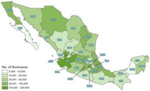
See the map below to understand our coverage by state:

What is Location-Based Data?

First, an explanation of exactly what location-based data is and why it’s important. Also known as ‘location intelligence,’ location-based data displays information layered onto a map. It shows how various points of information spatially relate to each other, helping to support analysis and decision making.

Maps bring information to life, allowing you to understand information and relationships geographically, and uncover valuable insights.

How Location-Based Data Helps You When Doing Business in Mexico

Growing any business involves risk and reward. Risk increases when expanding into a new market. Foreign competition in Mexico is growing as more businesses recognize the advantages of doing business there. This means you need to identify the best opportunities quickly and act on them as soon as possible. Making effective decisions begins with leveraging accurate location-based data.

Once you’ve evaluated your needs, you need to do research and analysis to support your objectives. Location-based data allows you to get very familiar with target geographies or industries, helping you to find the most cost-effective dataset.
For example, if you’re looking for people and companies you want to do business with, here’s a summary of the data fields available:

  • Industry Sector
  • Major SIC Category (2 Digit)
  • Sub SIC Category (4 Digit)
  • Product or Service Description
  • Company Name, Address, Colonia, City, State, Zip/Postal Code

Also, our location-based data can be delivered as a complete dataset or as a subset. Here are our most popular subsets:

  • Point of Interest (POI) Dataset
  • Mexico Manufacturers Dataset
  • Mexico Email Dataset
  • Mexico Importers and Exporters Dataset
  • Mexico Wholesalers & Distributors Dataset
  • Mexico Retailers Dataset
  • Mexico Head Office Dataset

Additionally, if you need a subset of businesses located near an airport or other transportation hubs, contact us. If you need a subset of businesses located near a particular distribution center or closer to an agricultural area, all of this information is easier to see and understand when it’s on a map.

Doing Business In Mexico: Use Data to Save Costs and Drive Revenue

Instant access to Mexico business data will improve your potential for expansion and growth. It will help you determine the best options for cost-effective solutions, as well as identify how you can mitigate risk. For example, accurate location data helps your company identify the best locations for doing business, and the best people and companies within those locations that will help your company realize its objectives.

You’ll be able to make effective decisions faster than your competitors with the right location data, helping you to meet the growing demands of your business and facilitate growth. However, that data needs to be accurate and timely to positively impact business outcomes. When seeking business opportunities in Mexico, location data needs to be flexible, allowing you to filter and manipulate data so that you can analyze it according to your specific business needs.

The Largest Source of Location-Based Mexico Business Data

Accessing location data in large countries can be a major challenge. Many businesses come across unexpected obstacles to accessing the information they need, including bureaucratic issues, and cultural and language barriers. Once information is found, it’s difficult to determine if it’s accurate and reliable. To maximize your use of the data, you need to ensure that it’s accurate, continually updated, and will flow freely into your hands when you need it.

For companies looking to grow in Mexico, Digital Map Products offers the largest and only location-enabled dataset for Mexico business data. Contact us to learn about available data and pricing.

Want to see a sample of the data and how it’s structured?

Click here to download a sample dataset.

GIS Mapping Software

A Lesson in Map-Folding Origami

Do you use maps? I’m fairly certain you do, possibly a GIS mapping app on a daily basis. When I was 16 and learning to drive maps were these sticky, dirty, impossible to fold, gigantic pieces of paper I always managed to rip while shoving back into the glove box. “You be the navigator, I’ll be the driver.” Remember those days?

Today we don’t have to worry about map origami (seriously, who actually folded it right the first time?!). I personally have 2 mapping apps on my Android, both of which have totally different purposes.

GIS Mapping Apps in order of favouritism:

1) Waze – Hands down one of the most fun and accurate traffic applications out there. Excellent UI and hilariously fun Voice Navigation, (I highly encourage everyone to try “Boy Band”). This app is intended to effortlessly navigate you through high traffic and accident-prone areas. Definitely my choice of app when it comes to getting from A to B.

2) Google Maps – With over 4.8 million Android users alone, this application is well known for its pros and cons. While it is definitely the easiest application to operate, it nearly never locates my gps position in under 5 minutes. This is my app of choice when looking up an area or trying to find a specific address.

You will notice these apps are very centered around my inability to navigate when driving, or using transit. How else would I use maps as a consumer?

Here’s Why the Average Person Needs a GIS Mapping App:

  • Get me from Home to ‘X’
  • Get me from Work to ‘X’
  • Find me the closest Subway to ‘X’

Pretty simple isn’t it? Not if you’re a Business.

Using GIS Mapping Software in the Business World

Maps in the business world are complex. Heck, that’s why we have GIS mapping apps. As this Esri link tells us, nearly every business benefits from understanding their environment. Better decision making, cost savings, etc. Whether you are in Retail, Land Development, or Health Care, it matters to know where your Customers/Clients are located. Better yet, if you have a GIS professional on your team – they can build you a map!

Take Health Care for example. DMTI Spatial worked with the Ontario Medical Association to understand where their Physicians were located in relation to the population in Ontario. While this exercise sounds easy, it was a complex project that resulted in a table of over 142 billion records – one of the largest data deliveries in DMTI’s 20 year history. Where your Customers are located matters.

Now consider Retail. What if you found out your most loyal customers (aka the ones that spend the big bucks) are located within 10 km of your store. Would you consider marketing to these neighbourhoods? Or divert marketing dollars that were intended for a 30km + distribution?

Today we use maps to make business decisions. Only these maps are digital, and sometimes come with a boy band singsong voiceover (again, I highly suggest it).

Want to integrate a basic map into your Business process? Want to visualize where your customers are? Let me know and I can help. But, I can’t fold that blasted paper map back up for you.