With a large number fires burning in Canada over 2015—some in close to populated areas—now’s the time to discuss wildfire risk and the impact it could have on your business.
- 5,500 people are evacuated from 10 communities in Canada every year
- 20 communities with about 70,000 people are threatened by large fires every year
Forest Fire Classification
Forest Fires (wildfire) are classified by the current status of the fire. The chart below explains wildfire status.
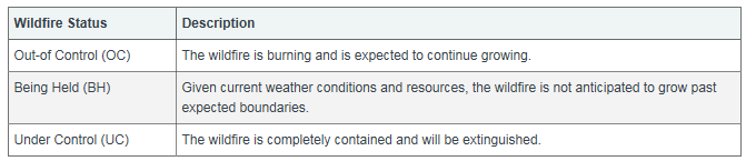
Source: Alberta Environment and Sustainable Resource Development, 2015.
What Happens When Land is at Risk?
There is typically an evacuation alert/evacuation order or a State of Emergency when properties and customers could face wildfire.
Insurance companies and financial institutions use the status of the event to answer questions such as:
- How can we define event boundaries?
- How do we determine whether to continue to write policies within that region?
- What’s the risk of fire in a specific region, and how many customers would be affected?
The ability to align internal stakeholders and respond quickly as a business unit is imperative.
Using Maps to Understand Wildfire Risk
Use an event boundary for analysis when trying to understand the impact of a fire on your book of business. Data visualization tools can help.
Consider the following categories of location information available to you in your datasets:
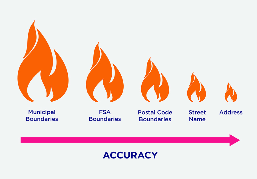
When determining where to write policies or mortgages during one of these events, accuracy is key. Municipal boundaries, Forward Sortation Area (FSA) boundaries, and postal code boundaries (particularly in rural areas) are too large and can result in companies unnecessarily turning away new business during a contained event.
Leveraging street names provides a more accurate representation of the impacted area, and geo-coded address records provide the most granular and accurate information related to an impacted area.
DMTI Spatial’s Unique Address Identifier (UAID®) assigned to addresses enables companies to quickly determine an event’s direct impact on their book of business, and share across internal and partner networks to quickly determine a plan of action.
How can organizations prepare?
- Seek a data visualization tool that provides timely and advanced insight into the duration, size, impact and number of addresses affected by an event so you can easily share exposure information across your organization.
- National insights in real-time
- Take advantage of an offering that delivers property level event information and other perils that may impact your book of business.
How can I learn more?
- Contact us to learn more about how you can leverage Location Hub Post Event Service to stay on top of events that impact your business.

