Are Insurance Companies Measuring Flood Risk Accurately?
On Feb 19 2015, Aviva Canada announced the availability of overland water endorsement. This meant homeowner coverage in Ontario and Alberta would start in May, and roll out to additional provinces throughout 2015.
In Canada, we now have national flood hazard maps and the ability to easily map each of our policies.
“What gets measured, gets managed” – Peter Drucker
Data Visualization Tools for Flood Risk
Patrick Lundy (CEO) of Zurich Canada said:
“Having the right tools, maps and predictive models is key to charging an accurate price for the risk, and capacity in certain areas may become harder to come by. Updated flood zone maps for Canada are of the utmost importance in being able to respond accurately to the increased flooding activity.” (Canadian Underwriter, 2013)
Today, insurance organizations have the ability to:
- Identify and assess significant exposures in their portfolio
- Identify new business without growing their 1/n year flood loss
- Determine where they should not write new business
- Identify flood risk which may require a more detailed assessment
“Opportunities multiply as they are seized” – Sun Tzu
Insurance Bureau of Canada (IBC) identified that overland flooding is a risk, but this is for a small percentage of the population. This refers to those who live in floodplains or flood prone areas close to rivers or lakes.
Leveraging this knowledge may lead to the creation of a new niche product offering for overland flood.
“Once we know something, we find it hard to imagine what it was like not to know it” – Chip & Dan Heath, Authors of Made to Stick, Switch
The Real Flood Risk
Van Bakel of Crawford recalled discussions that insurance companies shouldn’t worry about catastrophic events, and that everything was accounted for internally.
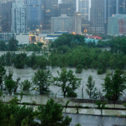
“Fast forward about six weeks. Two of the most populated areas of Canada would never flood within two weeks of each other, would they?”
Overland flood hazard maps and precise mapping (or geocoding) technology allows insurance companies to:
- Understand the risk to your book of business
- Identify which markets may have flood risk
- Create new pricing models based on this risk
- Generate new product revenue for the business
Click here to learn more about how your book of business may be impacted by overland flood in Canada, or contact us at info@dmtispatial.com.


